What is the Kamb Ice Stream? Within the last ~10,000 years the West Antarctic Ice Sheet lost about half of its volume and concerns have been raised about the possibility of its further retreat or collapse in the near future. Such retreat and collapse could raise the global sea level by several meters, contributing to the near-future sea-level rise due to anticipated global warming. A large fraction of this mass has been lost through the fast-flowing ice streams of the Ross Embayment. Yet these ice streams themselves are undergoing change currently with the stoppage of Ice Stream C (ISC) ~150 years ago and to the slowdown of the Whillans Ice Stream that has continued for the last several decades. In order to evaluate the near-future contribution of the WAIS to sea-level changes we need to understand important aspects of the ice-stream stoppage process, such as: the mechanism of ice stream stoppage, whether such stoppage can affect other ice streams in the near future and whether the stopped ISC may restart in the near future? This project is a collaboration between ourselves at St. Olaf and scientists at the University of California Santa Cruz. We are using ground-based ice-penetrating radar and GPS to investigate: (1) along-flow variation in bed properties, (2) deformation of internal reflectors, (3) temporal and spatial patterns of horizontal and vertical components of ice-surface velocity. The data will be used to verify whether ISC is already experiencing a surge and to infer how long the current inactivity of the ice stream may persist. Science and Results Background The St. Olaf College contribution to the US-ITASE program is a deep-penetrating radio echo-sounding system that can measure the bedrock surface beneath the ice as well as internal layers that have unique electrical properties. Total ice thickness data is useful to researchers who develop ice-flow models of the ice sheet. The immense size of the ice sheet makes it difficult to obtain high-accuracy thickness measurements over the entire continent. The long distance traverses of the US-ITASE program make it an ideal platform for ground-based radar measurements. Internal ice reflections are usually related to deposition of volcanic debris (acids or ash) or dust layers. These layers give researchers a window into the accumulation and flow history of the ice sheet. Changes in the layer thickness along the traverse routes may be attributed to changes in snow accumulation due to climate or geographic changes (crossing a drainage divide, for example). Changes in the ice flow velocity due to bumps in the bedrock or changes in the bedrock character cause the ice to thicken or thin as the ice decelerates or accelerates.
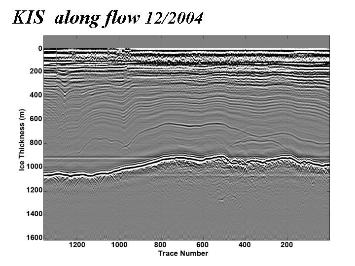
Results, Publications & Data At this point (spring 2005) we have completed two field seasons on the ice stream and have some preliminary results from the radar. The first image below shows a radar profile from a longitudinal section of Kamb Ice Stream. The bed topography is revealed at a depth of approximately one kilometer and internal stratigraphy can be resolved throughout most of the ice thickness. The internal layers are deformed by the ice stream flow and are not conformal with features at the bed. Similar images acquired by us in this location in 1987 may enable us to measure three-dimensional strain rates throughout the ice thickness.
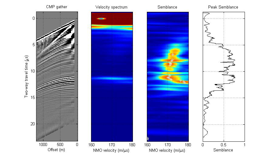
The next image shows the results of a "constant midpoint profile" where the radar transmitter and receiver have been moved in increments of 10 meters away from a common center and echoes from this "constant midpoint" have been stacked across the plot. This kind of profile enables us to image reflectors from the midpoint, both at the bed and throughout the ice thickness, from a range of angles (hyperbolas at the left). By solving simultaneous equations for the travel time to a fixed point over multiple paths we can accurately determine the average velocity as a function of depth (the semblance) and ultimately extract dielectric properties of both the internal reflectors and the bed using the amplitude variation of the echoes..
Instrumentation & Methods We operate a 3 MHz radio echo-sounding system to transmit and receive radio waves through as much as 3 km of ice. This signal frequency translates to a wavelength of about 56 m in ice. The transmitter (made by the University of Washington) emits pulses at frequency of 250 Hz. The pulses are emitted by our transmitter antenna, a 40 m dipole dragged along the snow surface. 135 m in front of the transmitter is an identical dipole antenna that receives the signal. The signal is amplified and passed on to an oscilloscope board mounted directly on a field-hardened PC computer. The scope board identifies the incoming signal, digitizes it, and sends it to the computer to be stored on the hard drive. The scope board is extremely fast, sampling the signal at up to 100 million samples/second. Each sample of the signal is digitized to a 14-bit number meaning that the board is capable of processing up to 1.6 Gigabytes of signal data every second! Fortunately we don't record data at such a fast rate, but use the board's speed to stack the incoming signal to remove much of the environmental radio noise that hides our reflected signal. We stack the data by averaging a few thousand of the transmitter pulses and their resultant echoes from the bedrock and internal layers. The traverse train travels at about 12 km/hr so we generally stack 1200-1500 traces every 10-12 meters. Stacking and the fast scope board allow us record a dense profile of traces while eliminating much of the noise that would make the data difficult to process and interpret.
Field Logistics The system and operator are towed by a snow machine. The receiver and operator are housed in a small shelter built on a wooden Komatik sled. The shelter protects the computer and operator from wind, cold, and snow. Power for the receiver is provided either by a solar-powered battery system, or a small gas-powered generator mounted on the back of the sled. The generator also provides power for battery chargers when needed. The transmitter batteries are recharged by the solar panels or generator. The shelter is also equipped with a GPS receiver to locate the data points. A survival bag is strapped to the front of the shelter in case of emergency. The transmitter is towed 100 m or more behind the receiver sled. The transmitter and its battery sit in a small sled and are protected from the elements by the sled's nylon cover. The antennas for the transmitter and receiver are housed in strong rubber hoses and tied to the tow ropes to keep the antennas as straight and parallel as possible.
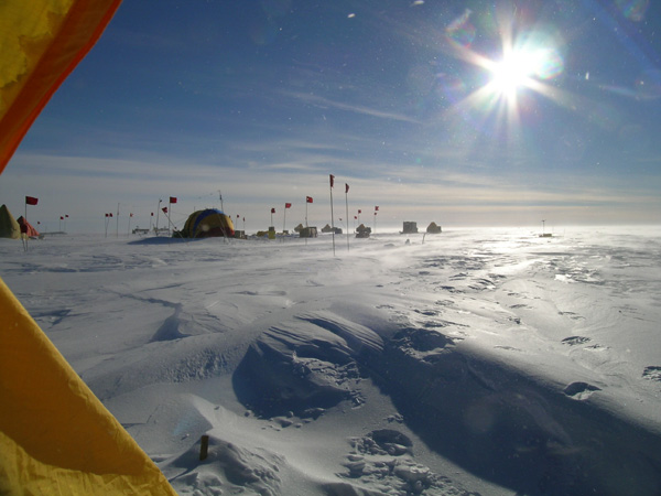
Photos from Kamb Ice Stream
   As a cooperative research project there are numerous universities, organizations, and individuals involved in bringing the science together. Many of those groups are listed here. Other links connect to sites related to polar research, exploration, weather, etc. Universities & Research Institutes of Kamb Ice Stream Project Dr. Slawek Tulaczyk:
Dr. Ian Joughin St. Olaf Contacts Dr. Robert W.
Jacobel Rickard Pettersson St. Olaf College Undergraduate Researchers Ian Campbell: David Osterhouse: Support Agencies & Logistics National Science Foundation: Raytheon Polar Services Company: Weather Conditions in Antarctica
|