The appropriate field methods for gathering Radio-Echo Sounding (RES) data depend upon the objective of the survey. If a researcher simply wants a rough estimate of the glacier thickness, only a couple readings might suffice. If a high-resolution map of the glacier bed is desired, a dense grid of measurement points is necessary. Below is a description of the field techniques used to develop a high-resolution map of the glacier bed. It is important to remember that even after the field work is over there are many hours of data processing to be done. The techniques described here were developed to minimize the processing time and to maximize the resolution of the resulting map.
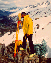
When processing and interpreting the RES data after the field season, the researcher needs to know the topography of the glacier surface to correct for changes in the recorded wave travel times. The glacier surface topography is mapped using the Global Positioning System (GPS) or by traditional optical surveying. While GPS is faster, it does not have the vertical or horizontal resolution of optical surveying. The horizontal positions are necessary to locate the map with respect to other maps of the area, while the vertical coordinates are critical for the data processing and need to be accurate to within 0.5 m.
In order to reduce the possibility of spatial aliasing and to maximize the resolution of the RES survey, the traces should be recorded less than one-quarter wavelength apart. For example, a 5 MHz RES system produces a 34 m wavelength. Therefore the grid of RES traces should be less than 8.5 m apart.
A rectangular grid with the traces aligned at 90° to one another greatly simplifies the data processing. Unfortunately, field conditions do not always oblige such an orderly system and the grid is modified by the presence of crevasses, melt-water ponds, steep slopes, avalanche debris, etc. In such cases, detailed notes help to recreate the grid during the data processing.
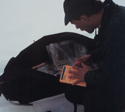
The transmitter and receiver occupy separate sleds. These may be pulled in-line or side-by-side depending on the design specifications of the instruments. The Univ. of Wyoming system is pulled side-by-side so that the transmitter and receiver are pulled parallel to one another. A single researcher pulls the transmitter on its homemade sled while another pulls the receiver sled. A third researcher walks beside the receiver sled to monitor the incoming signals on the oscilloscope and then record them to the laptop computer.
Some systems can continuously record traces to a computer and do minor amounts of pre-processing such as trace stacking (or averaging) and digital filtering to remove noise. The Univ. of Wyoming system is much simpler requiring the researchers to stop at each position in the RES grid and manually tell the computer to retrieve data from the oscilloscope. Although more time consuming, this method allows the researchers to monitor the condition of the incoming data and results in a smaller data set. Each trace recorded onto the computer is an average of at least 64 received pulses from the transmitter so that the signal-to-noise ratio is improved.
The Worthington Glacier is a small temperate valley glacier in the Chugach Mts. of South-Central Alaska. Radio-echo sounding surveys have been recorded there in support of ice-dynamics research by the Univ. of Wyoming and the Institute of Arctic & Alpine Research at the Univ. of Colorado. Follow the map links to see the location of the Worthington Glacier. View a Virtual Reality scene of the Worthington Glacier (requires VRML viewer).
![]() Return to Main
Radio-Echo Sounding Page
Return to Main
Radio-Echo Sounding Page
Updated: August 03, 2011
© 1998, Brian C. Welch,
Univ. of Wyoming