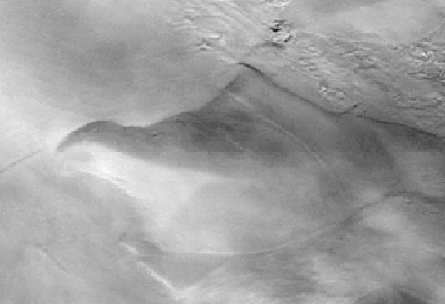
AVHRR satellite image of Siple Dome at the eastern edge of the Ross Ice Shelf. North is approximately up in this view. Photo description: The scene is approximately 500 by 300 km with north toward the top. Ice Streams C and D flowing from the West Antarctic Ice Sheet enter the scene at the right (see flowbands and more mottled topography) and divide around the smoother-appearing dome as they join the Ice Shelf. Using radar observations, we have determined that the curvilinear scar on the northeast flank of the dome is the margin of a relict ice stream which traversed the dome prior to about 2700 years ago. Higher resolution Landsat TM and SPOT satellite imagery can be used to obtain velocity measurements of the ice surface. |
|
With help from our colleagues at NASA Goddard,
we have developed software for coregistering repeat satellite images of
portions of the ice streams area, and searching these with a pattern-recognition
algorithm to determine displacements of surface features such as crevasses.
This enables us to find velocity fields of the ice surface, and we have
used this technique to find velocities near the relict ice stream margin
feature traversing the northwest flank of Siple Dome. These velocities indicate
that the ice in this location is moving an order of magnitude faster than
typical interstream ridge ice and supports the hypothesis that an ice stream
formerly crossed the flank of Siple Dome. We have also developed routines
for combining Landsat TM scenes into a mosaic, and these products were used
to help plan and carry out our recent field work at Siple Dome.
|