| Re-imaging Joseph N. Nicollet's mapmaking Expedition through the Undine Region of Minnesota and Iowa |
|
September 18, 1838
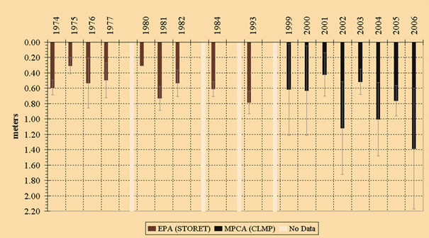
Mean annual secchi depth for Cannon Lake, ID#66-0008, located in Rice County, MN. Data from the MN Pollution Control Agency (MPCA) Citizens Lake Monitoring Program (CLMP) and the STORET database at the U.S. Environmental Protection Agency (EPA). Error bars show one standard deviation of reported measurements. Over the three decades of data, secchi depth averages about 0.07 meter. In the 2000s, transparency significantly increases to around one meter depth.
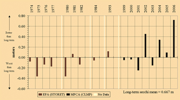
Mean annual secchi depth relative to the long-term average for Cannon Lake, ID#66-0008, located in Rice County, MN. Data from the MN Pollution Control Agency (MPCA) Citizens Lake Monitoring Program (CLMP) and the STORET database at the U.S. Environmental Protection Agency (EPA). Graph depicts long term secchi depth average as zero over the entire data set. Deviations above zero show transparency greater than the long-term average and deviations below zero correspond to transparency less than the long-term average. Note the improved transparencies in the early in the 2000s.
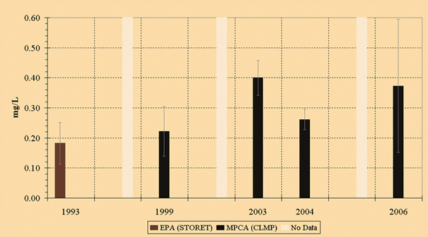
Past and current total phosphorus levels for Cannon Lake, ID#66-0008, located in Rice County, MN. Data from the MN Pollution Control Agency (MPCA) Citizens Lake Monitoring Program (CLMP) and the STORET database at the U.S. Environmental Protection Agency (EPA). There are approximately five measurements per year obtained between May through September. Error bars show one standard deviation of reported measurements. Phosphorus levels appear to increase in the 2000s compared to the 1990s. Note the large standard deviation in the 2006 data due to a love observation of 0.065 mg/L in May. |